
CIT Sewer Solutions
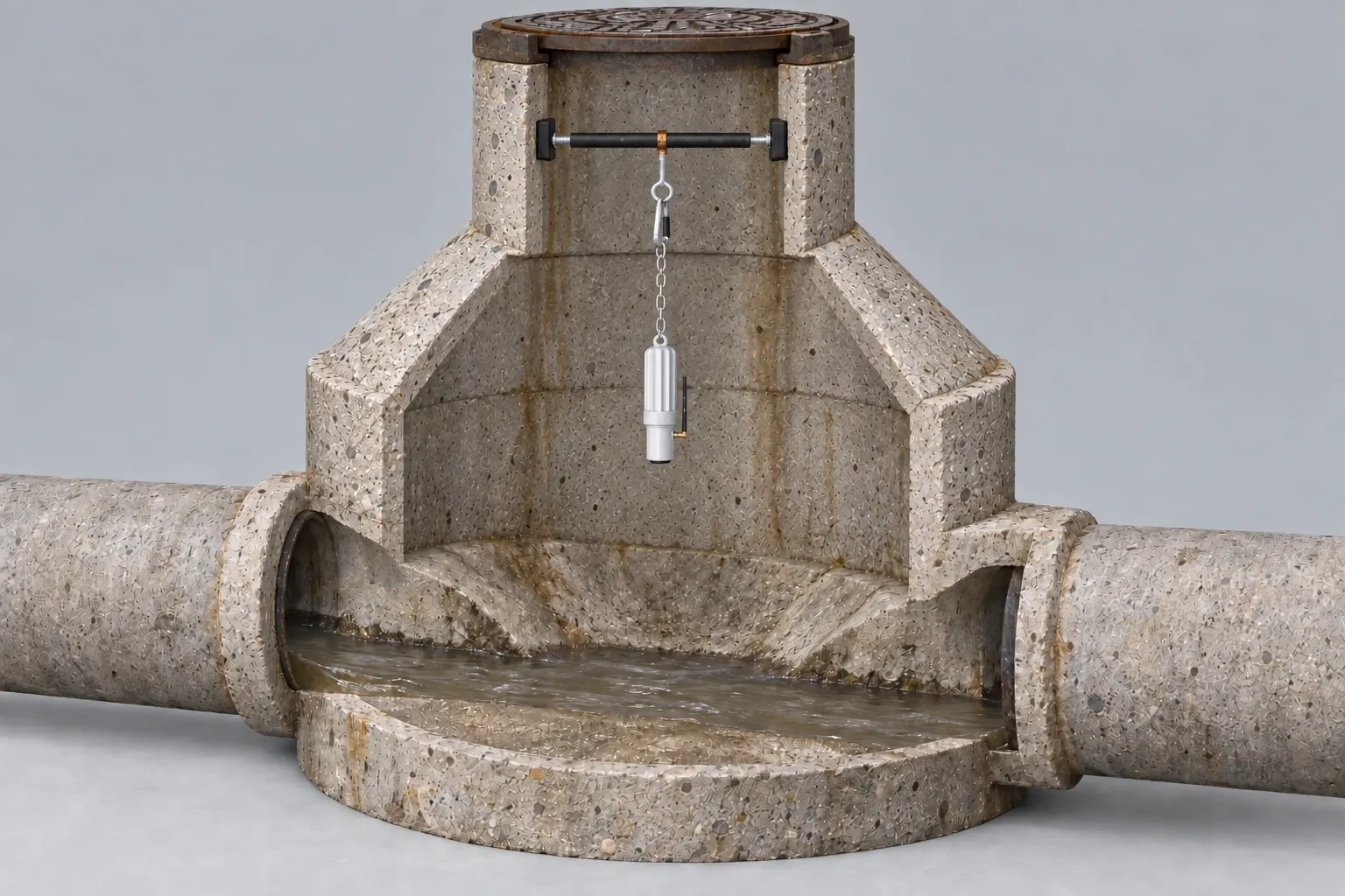
Cutaway illustration of an Eastech iTracker suspended by a chain and eyelet from a padded expansion bar across the straight manhole neck, above the wastewater channel.

Temporary sewer flow monitoring

We track how rain changes the levels in your sewer.

When rain pushes more water through your sewer, the increase at your lift station does not tell you which upstream area is responsible. We use temporary Eastech iTracker level sensors and rainfall records to compare your sub-basins, then identify the areas to investigate for inflow and infiltration (I&I).

Discuss your sewer flow monitoring.

We use your details to respond to your inquiry. You can submit it with internal analytics turned off. Read our Privacy Policy.

Service illustration

Cutaway illustration of an Eastech iTracker suspended by a chain and eyelet from a padded expansion bar across the straight manhole neck, above the wastewater channel.
An expansion bar spans the straight manhole neck. Its eyelet and chain suspend the iTracker above the wastewater.Service illustration

01

We record your sewer levels without placing a probe in the flow.

Our crew suspends an Eastech iTracker above the wastewater at selected manholes. The non-contact sensor records changes in level over time and stores the readings in its onboard data logger. Bluetooth capability allows the readings to be retrieved for analysis.

We select manholes that separate your sewer into useful comparison areas, called sub-basins. Monitoring these locations gives your utility or engineer a way to compare the upstream areas contributing to the same downstream sewer.
02

We compare your dry-weather levels with the response to rain.

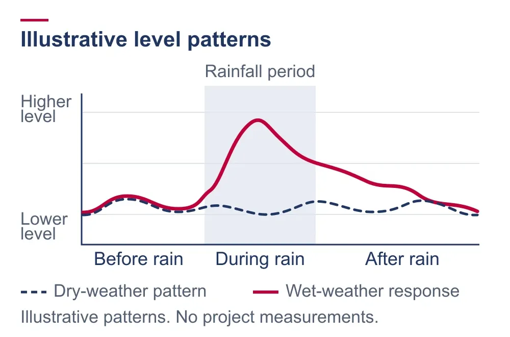
Illustrative chart compares a dashed dry-weather level pattern with a higher wet-weather response during and after rain; no measured values are shown.
Comparing your level pattern with rainfall helps us identify the timing and persistence of a wet-weather response.Service illustration

We match the recorded sewer levels with rainfall from the same period. Your normal daily pattern provides a baseline for reviewing when levels rise, how far they rise and how long they remain elevated after a storm.

A rapid rise during rain and a longer response after rain suggest different entry patterns to investigate. Direct connections can admit stormwater, while groundwater can enter through damaged joints and other defects. A level trace alone does not separate every source or prove which joint is leaking.

03

We prioritize your sub-basins before source testing begins.

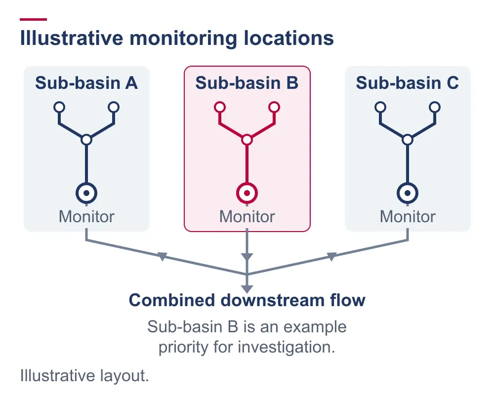
Illustrative sewer network with monitors at three sub-basin outlets before their flows join; one sub-basin is highlighted for further investigation.
Monitors at your sub-basin outlets help distinguish upstream responses before the flows combine.Service illustration

You receive a prioritized list of basins and structures to investigate. We use the monitoring comparison to focus smoke testing and inspection within your connected sewer network. Monitoring can also accompany your manhole condition assessment, so the wet-weather response can be considered alongside visible leakage and deterioration.

Our crew uses smoke testing to screen for possible entry paths. Dye testing and back smoking investigate suspected connections; camera inspection and manhole assessment examine visible pipe and structure conditions. Those findings help identify the damaged joint, connection or structure that needs corrective work.

01

We record your manhole walls, joints and connections for rehabilitation planning.

Our crew lowers an illuminated 360-degree camera into your manhole, and our technicians review the captured surfaces for visible leakage and deterioration. We inspect individual structures, targeted sewer basins and wider municipal inventories.

Our municipal assessment package includes the selected MACP Level 1 or Level 2 assessment, models or point clouds, shareable reports, GIS-ready data and technician review. We use SewerAI in our manhole assessment work. Your staff and engineer can revisit the recorded structure when comparing rehabilitation needs.

02

Find your project location in our service area.

We serve municipal, commercial and institutional sewer projects in Iowa, Minnesota, Missouri, Nebraska, Arkansas and Colorado. Tell us where your sewer is located and which assets need inspection, maintenance or repair so we can discuss the project requirements and scheduling.

Our local sales territories cover all 99 Iowa counties, six eastern Nebraska counties and Union County, South Dakota. The territory pages list their communities, counties and CIT contacts. For projects elsewhere in our six-state service area, use the full service-area page.

Plan temporary monitoring for your collection system.

What does the iTracker measure?
The iTracker is a non-contact level sensor. It records how the wastewater level changes at its monitoring location. We compare those readings with dry-weather patterns and rainfall to investigate wet-weather behavior. A level reading is not a direct velocity measurement or a billing-meter result.
How long should we monitor our sewer?
The monitoring period needs to capture useful dry-weather conditions and the wet-weather response your team wants to investigate. We plan the locations and duration around your collection system and the available rainfall; one fixed period does not suit every project.
Can monitoring tell us which pipe joint to repair?
Monitoring helps prioritize your sewer areas for investigation. A rise in level alone does not identify a leaking joint. We use appropriate source testing and inspection to investigate suspected entry paths before identifying corrective work.

Discuss Your Project

Discuss the wet-weather increase in your sewer.

Tell us where your project is and what changes your team sees during rain. We can discuss where to place the monitors and which sewer areas need further investigation.

Call 515-434-2248